Table of Contents
Introduction
Jharkhand, the 28th state of India, was carved out of the southern part of Bihar on November 15, 2000. Situated in the eastern part of the country, Jharkhand is known for its rich cultural heritage, diverse geography, and vibrant communities.
Jharkhand is a state in eastern India, bordered by West Bengal, Chhattisgarh, Uttar Pradesh, Bihar, and Odisha. It’s the 15th largest state by area and the 14th largest by population. The official language is Hindi, and Ranchi is the capital city, with Dumka serving as its sub-capital. Known for its waterfalls, hills, and religious sites like Baidyanath Dham, Parasnath, Dewri, and Rajrappa, Jharkhand is primarily rural, with about 24% of its population living in cities.
Despite being rich in mineral resources, Jharkhand faces significant challenges. More than 40% of India’s mineral resources are found here, yet 39.1% of its population lives below the poverty line, and 19.6% of children under five are malnourished.
The name “Jharkhand” comes from the words “Jhar” meaning ‘forest’ and “Khand” meaning ‘land’. So, “Jharkhand” translates to ‘forest land’. In ancient times, the region was referred to as Kark Khand due to its location near the Tropic of Cancer. During the medieval period, it became known as Jharkhand. According to historical texts, Jharkhand was one of the seven Pundra desas mentioned in the Bhavishya Purana (1200 CE). The name “Jharkhand” appears on a 13th-century copper plate found in the Kendrapada region of Odisha from the reign of Narasimha Deva II of the Eastern Ganga dynasty. In Akbarnama, the area from Panchet in the east to Ratanpur in the west, Rohtasgarh in the north, and the border of Odisha in the south was known as Jharkhand.
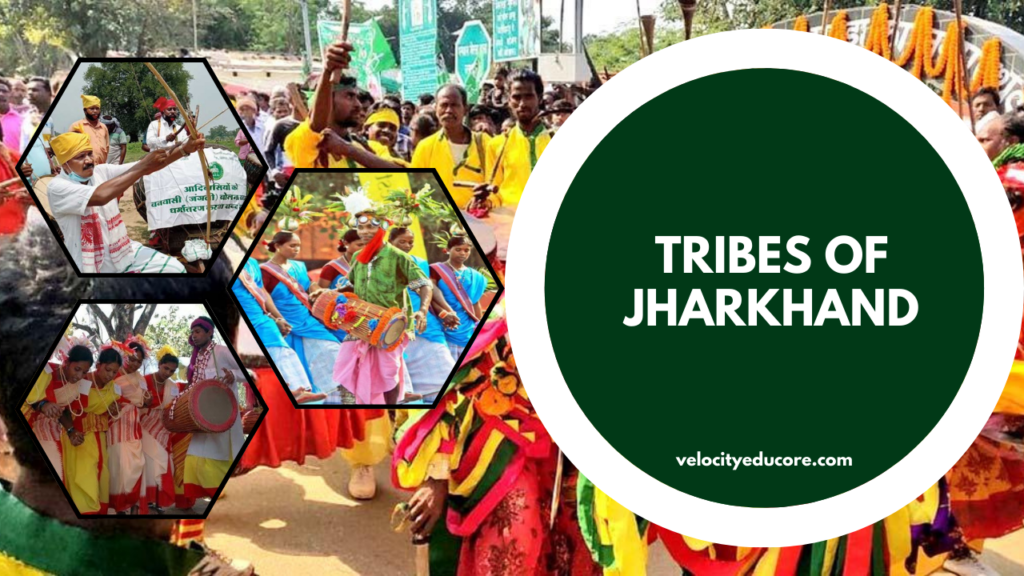
Home to some of the oldest tribes in India, including the Santhal, Munda, and Oraon, Jharkhand boasts a unique blend of tradition and modernity. With its lush green forests, rolling hills, and bustling industrial towns, Jharkhand offers a tapestry of experiences waiting to be explored.
Important Facts
- Jharkhand “The Land of Forests” is the 28th state of Eastern India.
- Formation/Created: 15 November 2000
- On 15 November 2000, a new state Jharkhand was formed by separating the southern portion of Bihar.
- Jharkhand shares its border with the states of West Bengal to the east, Chhattisgarh to the west, Bihar to the north, Odisha to the south and Uttar Pradesh to the northwest.
- Area: 79,716 km² (30,779 sq mi) • Length: 380 km
- Width: 463 km
- Official language: Hindi
- Capital city: Ranchi
- Sub capital: Dumka
- Jharkhand ranked 15th largest state by area and the 14th largest by population.
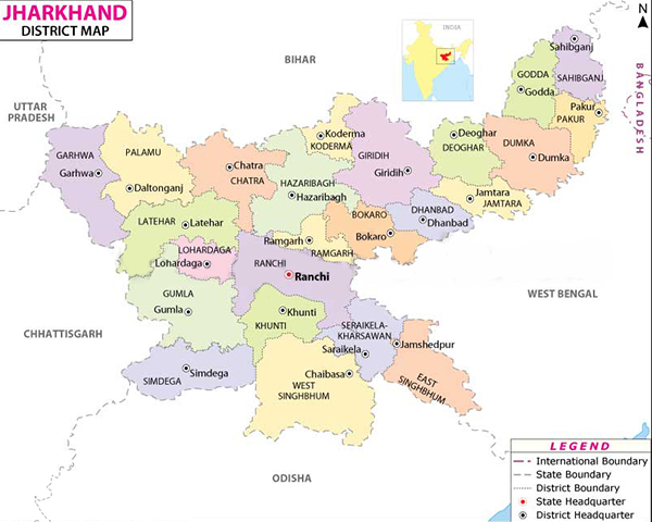
- No. of Districts: 24
- No. of Divisions: 05
- No. of Sub division: 38
- No. of blocks: 264 (Ref. Census 2011)
- No of villages: 32620
- Population: 3.3 crores (^Ref Census 2011)
- Till 4 March 2024
Governor: C.P. Radhakrishnan
Chief Minister: Champai Soren - No. of Rajya Sabha seats: 6
- No. of Lok Sabha seats: 14
- State flower: PALASH
- State bird: KOEL
- State mammal: INDIAN ELEPHANT
- State tree: SAAL
- Main Rivers in Jharkhand: Ganga, Son, Subarnarekha, Kharkai, Damodar, North Koel, South Koel, Lilajan (Falgu), Ajay, Mayurakshi, Barakar,etc.
- Hills and Mountain Ranges in Jharkhand: Parasnath, Netarhat, Rajmahal Hills, Trikut, Tagore Hill,etc.
- Official State website: https://www.jharkhand.gov.in/
- Emblem of Jharkhand:

CLICK HERE FOR MAP OF JHARKHAND
History of Jharkhand:
Ancient Period:
- The region has been inhabited since the Mesolithic-Chalcolithic period, as evidenced by ancient cave paintings and stone tools discovered in the Chota Nagpur Plateau region.
- Cave paintings in Isko, Hazaribagh district date back to the Meso-chalcolithic period (9000–5000 BCE).
- Copper tools became prevalent in the Chota Nagpur Plateau during the 2nd millennium BCE, marking the Copper Hoard Culture.
- Various artifacts dating from the Neolithic to the medieval period have been found in the Kabra-Kala mound in Palamu district.
- Iron slags, microliths, and potsherds dating back to 1400 BCE have been discovered in Singhbhum district.
- During ancient times, the region was ruled by several empires and dynasties including the Nanda, Maurya, and Gupta.
Medieval Period:
- In the 7th century, Chinese traveler Xuanzang described the region as Karnasuvarna, with Shashanka as its ruler.
- During the medieval period, the region was governed by Nagvanshi, Pala, Khayaravala, Ramgarh Raj, and Chero rulers.
- A Buddhist monastery dating back to the Pala period (10th century) has been found in Hazaribagh.
- Notable rulers during this period include Bhim Karn, a Nagvanshi king, and King Ram Shah who built the Kapilnath Temple in 1643.
- Chero rule in the Palamu region lasted until the 19th century when internal conflict weakened the Cheros, leading to their defeat by the East India Company.
Modern Period:
- During the 18th century, regions under various dynasties became part of the territories of the East India Company.
- The Chota Nagpur Plateau princely states came under the influence of the Maratha Empire but later became tributary states of the British East India Company.
- The British colonization led to spontaneous resistance from the local people, resulting in several rebellions such as the Chuar Rebellion (1767), Bhumij Rebellion (1779), and the Santhal Rebellion (1855).
- Thakur Vishwanath Shahdeo and Pandey Ganpat Rai rebelled against the British East India Company during the Indian Rebellion of 1857.
- After the rebellion, British rule transferred to the Crown in 1876, and the region witnessed several revolts against British rule, including the Birsa Munda revolt (1895-1900).
- In 1936, the Eastern States Agency was formed, bringing all nine states under its jurisdiction.
Post Independence:
- After Indian independence in 1947, many princely states acceded to the Dominion of India. Some regions became part of Madhya Pradesh and Orissa, while others became part of Bihar.
- In 1955, the Jharkhand Party, led by Jaipal Singh Munda, demanded a separate Jharkhand state comprising the tribal area of South Bihar, but the demand was rejected.
- In 1972, the Jharkhand Mukti Morcha, led by Binod Bihari Mahato, Shibu Soren, and A. K. Roy, was founded, along with the All Jharkhand Students Union, to lead the movement for a separate Jharkhand state.
- In 1988, various political parties came together to form the ‘All Party Separate State Formation Committee’ under the leadership of Justice Lal Pingley Nath Shahdeo.
- In 1998, the Union government decided to send a bill concerning the formation of the state of Jharkhand to the Bihar Legislative Assembly.
- The demand for a separate Jharkhand state gained momentum in the late 20th century, leading to the formation of political parties like the Jharkhand Mukti Morcha and the All Jharkhand Students Union.
- After years of struggle and political negotiations, Jharkhand finally became a separate state.
- On November 15, 2000, Jharkhand became a separate state, comprising the Chota Nagpur Division and Santhal Pargana Division of South Bihar, with Babulal Marandi as its first chief minister.
Jharkhand’s Formation and the Naxalite Uprising:
Jharkhand’s Formation:
- Jharkhand, carved out of the southern part of Bihar, became a separate state on November 15, 2000.
- With a population of over 20 million, the state is home to 28% tribal and 12% scheduled caste population.
- Jharkhand comprises 24 districts, 260 blocks, and 32,620 villages. However, only 45% of these villages have access to electricity, and merely 8,484 are connected by roads.
- Renowned for its mineral wealth, Jharkhand is the leading producer of minerals in India after Chhattisgarh. It is rich in iron ore, coal, copper ore, mica, bauxite, graphite, limestone, and uranium. The state is also known for its vast forest resources.
Naxal Uprising:
- Jharkhand has been a focal point of the Naxalite-Maoist insurgency since its uprising in 1967.
- It has resulted in the death of over 6,000 people in clashes between Naxalites and counter-insurgency operations by the police and paramilitary groups like the Salwa Judum.
- Despite occupying almost 7.80% of India’s geographical area and housing 5.50% of its population, Jharkhand is part of the “Red Corridor,” covering 92,000 square kilometers, where an estimated 20,000 combatants are engaged.
- The state’s abundant natural resources contrast sharply with the widespread poverty and destitution among its people, making it a fertile ground for communist insurgents.
- The insurgents argue that they are fighting on behalf of the landless poor and tribals who receive minimal benefits from resource extraction.
- As the federal government controls all sub-surface resources in the state, the tribal population is unable to claim any stake in the resources extracted from their land.
- In response, insurgents have targeted infrastructure related to resource extraction, particularly coal, essential for India’s energy needs.
- The violence associated with the insurgency was tragically highlighted on March 5, 2007, when Naxalite rebels shot dead Sunil Mahato, a member of parliament, while he was watching a football match during the Hindu festival of Holi near Kishanpur. His widow, Suman Mahato, won the subsequent Jamshedpur Lok Sabha by-election in September 2007 and served in parliament until 2009.
Geography
- Location: Jharkhand is situated in the eastern part of India and is bordered by West Bengal to the east, Chhattisgarh and Uttar Pradesh to the west, Bihar to the north, and Odisha to the south.
- Area: Covering an area of 79,716 square kilometres (30,779 sq mi), much of Jharkhand lies on the Chota Nagpur Plateau.
- Rivers: Several rivers flow through the Chota Nagpur plateau, including Damodar, North Koel, Barakar, South Koel, Sankh, and Subarnarekha. The state’s major rivers have their origins within Jharkhand.
- Forests: Jharkhand is mostly covered by forests, which are home to populations of elephants and tigers.
Climate
- Seasons: Jharkhand experiences five main seasons: summer, rainy, autumn, winter, and spring.
- Temperatures: During summer (mid-April to mid-June), temperatures range from around 37 °C (99 °F) during the day to 25 °C (77 °F) at night. Winter (November to February) sees temperatures ranging from 10–24 °C (50–75 °F).
- Rainfall: The southwest monsoon, from mid-June to October, brings nearly all of the state’s annual rainfall, ranging from about 1,000 mm (40 in) in the west-central part to over 1,500 mm (60 in) in the southwest.
Hills and Mountain Ranges
- Parasnath Hill: Situated in Giridih district, this hill is a major Jain pilgrimage site. It’s believed that 20 out of the 24 Tirthankaras attained Moksha (liberation) here.
- Netarhat: Known as the “Queen of Chotanagpur,” Netarhat is a hill station located in Latehar district.
- Rajmahal Hills: Located in Sahibganj and Godda districts, these hills belong to the Jurassic era and are known for their waterfalls, lakes, and greenery.
- Trikut: Situated ten kilometres away from Deoghar, Trikut Hill is known for its three major peaks.
- Tagore Hill: Also known as Morabadi Hill, it’s located in Morabadi, Ranchi. Rabindranath Tagore’s brother, Jyotirindranath Tagore, visited Ranchi in 1908.
Main Rivers
- Ganga River: Passing through the northeastern district of Sahebganj.
- Son River: Originating from Amarkantak, the river passes through Sidhi.
- Subarnarekha River: Originating from Chota Nagpur Plateau, it passes through Ranchi, Chandil, Jamshedpur, Ghatshila, and Gopiballavpur.
- Kharkai River: Originating from Mayurbhanj District, Odisha, it passes through Rairangpur and Adityapur before merging into the Subarnarekha River.
- Damodar River: Originating from Chota Nagpur Plateau, it passes through several cities including latehar, lohardaga, Ramgarh, and Dhanbad.
- North Koel River: Originating from the Chota Nagpur plateau, it passes through Daltonganj.
- South Koel River: Originating from the Chota Nagpur Plateau, it passes through Manoharpur and Rourkela.
- Lilajan River: Also known as Falgu river, it originates from the Northern Chota Nagpur Plateau and passes through Gaya.
- Ajay River: Originating from Munger, it passes through Purulia, Chittaranjan, Ilambazar, and Jaydev Kenduli.
- Mayurakshi River: Originating from Trikut hill, it passes through Suri.
- Barakar River: Originating from Padma in Hazaribagh, it flows through the districts of Koderma, Giridih, and Hazaribagh.
Biodiversity
- Jharkhand boasts a rich variety of flora and fauna. The state’s national parks and zoological gardens are home to diverse species.
- The Palamau Tiger Reserve, under the Project Tiger, hosts hundreds of species of flora and fauna, including mammals, snakes, lizards, fish, insects, birds, plants, and trees.
Government and Administration
Government Structure
- Constitutional Head: The governor, appointed by the President of India.
- Executive Power: Rests with the chief minister and the cabinet.
- Formation of Government: The political party or coalition with a majority in the Legislative Assembly forms the government.
Bureaucracy and Judiciary
- Chief Secretary: Head of the state bureaucracy.
- Bureaucratic Hierarchy: Comprises officials from the Indian Administrative Service, Indian Police Service, Indian Forest Service, and state civil services.
- Judiciary: Headed by the Chief Justice. Jharkhand has had a High Court since 2000. All branches of government are located in the state capital, Ranchi.
Administrative Divisions and Districts
- Districts: The state was formed with 18 districts that were formerly part of south Bihar. Six new districts were created: Latehar, Saraikela Kharsawan, Jamtara, Pakur, Khunti, and Ramgarh. Currently, the state has 5 divisions and 24 districts.
- Border Proximity: All districts, except Lohardaga and Khunti, share a border with a neighboring state.
Divisions and Districts
Palamu Division
No. of Districts: 3
- Garhwa
- Palamu
- Latehar
Headquarter: Medininagar
North Chotanagpur Division
No. of Districts: 7
- Chatra
- Hazaribag
- Giridih
- Koderma
- Dhanbad
- Bokaro
- Ramgarh
Headquarter: Hazaribagh
South Chotanagpur Division
No. of Districts: 5
- Ranchi
- Lohardaga
- Gumla
- Simdega
- Khunti
Headquarter: Ranchi
Kolhan Division
No. of Districts: 3
- West Singhbhum
- Seraikela Kharsawan
- East Singhbhum
Headquarter: Chaibasa
Santhal Pargana Division
No. of Districts: 6
- Deoghar
- Jamtara
- Dumka
- Godda
- Pakur
- Sahebganj
Headquarter: Dumka
Major Cities
Largest Cities in Jharkhand (2011 Census of India estimate)
| Rank | City | District | Population | Rank | City | District | Population |
|---|---|---|---|---|---|---|---|
| 01 | Jamshedpur | East Singbhum | 1,339,438 | 06 | Phusro | Bokaro | 186,139 |
| 02 | Dhanbad | Dhanbad | 1,196,214 | 07 | Hazaribagh | Hazaribagh | 153,595 |
| 03 | Ranchi | Ranchi | 1,126,741 | 08 | Giridih | Giridih | 143,630 |
| 04 | Bokaro Steel City | Bokaro | 564,319 | 09 | Ramgarh | Ramgarh | 132,441 |
| 05 | Deoghar | Deoghar | 203,123 | 10 | Medininagar | Palamu | 120,325 |
Demographics
Historical Population
- 1901: 6,068,233
- 1911: 6,747,122 (+11.2%)
- 1921: 6,767,770 (+0.3%)
- 1931: 7,908,737 (+16.9%)
- 1941: 8,868,069 (+12.1%)
- 1951: 9,697,254 (+9.4%)
- 1961: 11,606,489 (+19.7%)
- 1971: 14,227,133 (+22.6%)
- 1981: 17,612,069 (+23.8%)
- 1991: 21,844,911 (+24.0%)
- 2001: 26,945,829 (+23.4%)
- 2011: 32,988,134 (+22.4%)
Source: Census of India
Population
- According to the 2011 Indian Census, Jharkhand’s population is 32.96 million, consisting of 16.93 million males and 16.03 million females.
- Sex Ratio: 947 females to 1,000 males.
- Literacy Rate: The state’s literacy rate was 67.63%. Ranchi district has the highest literacy rate at 77.13%, while rural Pakur district has the lowest at 50.17%.
Social Demographics
- Scheduled Caste Population: 3,985,644 (12.08%)
- Scheduled Tribes Population: 8,646,189 (26.21%)
- Concentration: Concentrated predominantly in south-western districts such as Simdega (78.23%), Khunti (77.77%), Gumla (72.11%), Paschim Singhbhum (71.1%), Latehar (66.85%), and Lohardaga (60.21%).
Languages
- Most Spoken Languages (2011 Census):
- Khortha (23.46%)
- Hindi (21.40%)
- Bengali (9.74%)
- Santali (8.77%)
- Nagpuri (7.23%)
- Urdu (5.96%)
- Magahi (4.14%)
- Ho (3.01%)
- Mundari (2.92%)
- Kurukh (2.88%)
- ‘Other’ Hindi (2.32%)
- Bhojpuri (2.29%)
- Kurmali (1.82%)
- Odia (1.61%)
- Others (2.45%)
- Jharkhand is linguistically diverse, with speakers of Indo-Aryan, Dravidian, and Austroasiatic languages. While Hindi is the official language, regional languages include Nagpuri, Khortha, Kurmali, Magahi, and Bhojpuri. The state has also accorded official language status to Angika, Bengali, Bhojpuri, Bhumij, Ho, Kharia, Kurukh, Khortha, Kurmali, Magahi, Maithili, Mundari, Nagpuri, Odia, Santali, and Urdu.
Religion
- Major Religions (2011 Census):
- Hinduism (67.83%)
- Islam (14.53%)
- Unclassified (Sarnaism, 12.84%)
- Christianity (4.3%)
- Sikhism (0.22%)
- Other (0.08%)
- Not Stated (0.21%)
- Sarnaism: The unclassified religion mostly consists of adherents of Sarnaism.
- District-wise Religious Composition:
- Hindus: Majority in 19 out of 24 districts.
- Christians: Majority in Simdega district (51.04%).
- Sarnaism: Majority in Lohardaga (51.01%), West Singhbhum (62.29%), and plurality in Gumla (44.62%) and Khunti (45.37%).
- Muslims: Highest presence in Pakur (35%) and Sahebganj (34%) districts.
Economy
Gross Domestic Product (GDP)
- The gross domestic product of Jharkhand is estimated at ₹3.83 lakh crore (US$48 billion) in 2020–21.
- The per capita GDP of Jharkhand in 2018-19 was ₹82,430 (US$1,000).
Mineral Resources and Industries
- Jharkhand is endowed with immense mineral resources, making it a significant contributor to the Indian economy.
- Major minerals include iron ore (4th), coal (3rd), copper ore (1st), mica (1st), bauxite (3rd), manganese, limestone, china clay, fire clay, graphite (8th), kainite (1st), chromite (2nd), asbestos (1st), thorium (3rd), sillimanite, uranium (Jaduguda mines, Narwa Pahar) (1st), gold (Rakha Mines) (6th), and silver, among others.
- The concentration of industries is supported by large deposits of coal and iron ore, with major industrial centers like Jamshedpur, Dhanbad, Bokaro, and Ranchi.
- Tata Steel, a NSE NIFTY 500 conglomerate, has its corporate office and main plant in Tatanagar, Jharkhand, reporting a gross income of ₹204,910 million for 2005.
- NTPC is set to begin coal production from its captive mine in the state in 2011–12, with an investment of about Rs 18 billion.
Development Initiatives
- In February 2006, the government of Jharkhand established the Jharkhand Silk Textile and Handicraft Development Corporation (Jharcraft), promoting local sericulture, weaving, and the wider marketing of these products.
Agriculture
- Agriculture is a major economic sector in Jharkhand, with farmers producing a variety of crops including rice, wheat, maize, pulses, potatoes, and vegetables such as tomato, carrots, cabbage, brinjal, pumpkin, and papaya.
Other Industries
- Other significant industries in Jharkhand include the cottage industry and IT.
Culture
Cuisine
- Staple foods: rice, dal, vegetables, and tubers.
- Famous dishes: Chhilka Roti, Malpua, Pitha, Dhooska, Arsa roti, Dudhauri, Panipuri (Gupchup).
- Rugra and Putoo: edible mushrooms grown extensively.
- Bamboo shoots: versatile ingredient used in many dishes.
- Munga and Koinar leaves: used as a leafy vegetable or Saag.
- Local alcoholic drinks: Handia (rice beer) and Mahua daru.
Folk Music and Dance
- Folk dances: Jhumair, Mardani Jhumar, Janani Jhumar, Domkach, Vinsariya, Jhumta, Fagua, Angnai, Paiki, Chhau, Firkal, Mundari, Santali dance.
Festivals
- Major festivals: Sarhul, Baha Parab, Karam Parab, Mage Parab, Sohrai, Bandna, Tusu festival, Makar Sankranti, Nawakhani, Durga Puja, Jitiya, Manasa Puja,Dussehra, Rath Yatra, Saraswati Puja, Phagua, Sendra festival.
Paintings
- Sohrai and Khovar painting: mural art form practised by women.
Tattoo
- Godna: tattoo making tradition, an essential part of local culture.
Cinema
- Jhollywood: Film industry producing regional and Tribal language films.
Media
- Television channels: DD Jharkhand.
- Newspapers: Hindustan, Dainik Jagran, Sokal Sokal, Prabhat Khabar, Ranchi Express, The Hindu, The Times of India, Hindustan Times, Navbharat Times, The Pioneer, The Telegraph.
Transport
Air
- Birsa Munda Airport: largest domestic airport.
- Deoghar Airport: second busiest airport.
- Sonari Airport: third operational airport.
- Bokaro Airport: under construction.
- Other airports: Chakulia Airport, Dumka Airport, Dhanbad Airport.
Roads
- Extensive network of National Highways and State Highways.
- Paved National Highways: 2,661.83 km (1,653 mi 1,733 yd).
- National highways: 18, 19, 20, 22, 33, 39, 43, 114A, 118, 133, 133A, 133B, 139, 143, 143A, 143AG, 143D, 143H, 218, 220, 320D, 320G, 333, 333A, 343, 419, 522.
- Golden Quadrilateral: Delhi – Kolkata route.
Ports
- Sahebganj: planned multi-modal port.
- Estimated cost: ₹65,000 million.
- Phase-1 completion: 2019.
Rail
- Well-connected by railways.
- Numerous railway stations and railway junctions.
- Hilly regions equipped with tunnels.
Sports
- JRD TATA Sports Complex, Jamshedpur
- Hosts football matches of the Indian Super League.
- Home of ISL-based football club Jamshedpur FC.
- Cricket, hockey, and football are popular games.
- Notable Players:
- Jaipal Singh: Former Indian hockey captain and Olympian.
- Manohar Topno: Indian Hockey team player.
- Mahendra Singh Dhoni: Former captain of the Indian cricket team.
- Led India to ICC Cricket World Cup victory in 2011.
- Other notable cricketers: Varun Aaron, Shahbaz Nadeem, Saurabh Tiwary.
- Key batsman in the Indian team that won the 2008 U/19 Cricket World Cup.
- Deepika Kumari: Young archer, gold medalist in the 2010 Commonwealth Games.
- Nikki Pradhan: Member of the national hockey team, first female hockey player from Jharkhand to represent India in the Olympics.
- International Cricket Stadium
- Constructed with an indoor stadium and a practice ground.
- Hosted an International match between India and England on January 19, 2013.
- Hosted IPL matches and Celebrity Cricket League Matches.
- Tennis academy inaugurated by Sania Mirza and Shoaib Malik runs beside the cricket stadium.
- Ranchi in Hockey India League
- Ranchi franchise named Ranchi Rhinos.
- Co-hosted by Mahendra Singh Dhoni, now named Ranchi Rays.
Tourism
- Waterfalls, Hills, and Holy Places
- Major religious places: Parasnath, Baidyanath Dham, Maa Dewri Temple, Chhinnamasta Temple.
- Tattapani Hot Water Spring: Located 8 km from Latehar, believed to have medicinal properties.
- Itkhori: Holy place for Hindus, Buddhists, and Jains. Believed to be Gautama Buddha’s starting point for Bodh Gaya journey.
- Rankini Temple: Famous in Jharkhand, Odisha, West Bengal, and Bihar.
- Waterfalls: Jonha Falls, Hundru Falls, Dassam Falls, Perwaghagh Falls, Panchghagh Falls.
- Netarhat: Hill station.
- Attractions and Wildlife Sanctuaries
- Betla National Park and Dalma Wildlife Sanctuary: Major tourist attractions.
- State Museum Hotwar and Tribal Research Institute and Museum
- Showcase various cultural heritage and tribal culture of Jharkhand.
Education
- Literacy Rate
- According to the 2011 census, the literacy rate in Jharkhand was 66.41%.
- Male literacy rate: 76.84%
- Female literacy rate: 55.42%
- Nine districts with above-average literacy rates:
- Ranchi: 76.06%
- East Singhbhum: 75.49%
- Dhanbad: 74.52%
- Ramgarh: 73.17%
- Bokaro: 72.01%
- Hazaribagh: 69.75%
- Simdega: 67.99%
- Saraikela Khasawan: 67.70%
- Lohardaga: 67.61%
- Koderma: 66.84%
Schools
- Medium of instruction: Hindi/English
- Second language: English/Hindi/Sanskrit/Bengali/Odia
- After 10 years of schooling, students can pursue two years of Intermediate courses (or +2 courses) in Arts, Science, and Commerce.
- Followed by three years of degree courses (graduation) or four years of Engineering/Agriculture/Medicine degrees.
- Government and private schools are abundant.
- Notable schools: St. Thomas School, Ranchi, Sainik School Tilaiya, Loyola School, Jamshedpur, Delhi Public School (Bokaro and Ranchi), Bishop Westcott Boys’ School, Ramakrishna Mission Vidyapith, Deoghar, De Nobili School, and St. Xavier’s School, Hazaribagh.
- Franz Gastler established Yuwa School, an NGO in Hutup village, Ranchi district, to use football to combat child marriage, illiteracy, and human trafficking in rural India.
- In 2019, it won the Laureus Sport for Good Award.
Universities and Colleges
- Universities:
- AISECT University, Jharkhand, Hazaribagh
- Arka Jain University, Jamshedpur
- Binod Bihari Mahto Koyalanchal University, Dhanbad
- Birsa Agricultural University, Kanke, Ranchi
- Central University of Jharkhand, Brambe, Ranchi
- Jharkhand Rai University, Ranchi
- Jharkhand Raksha Shakti University, Ranchi
- Kolhan University, Chaibasa
- National University of Study and Research in Law, Ranchi
- Nilamber-Pitamber University, Medininagar
- Radha Govind University, Ramgarh
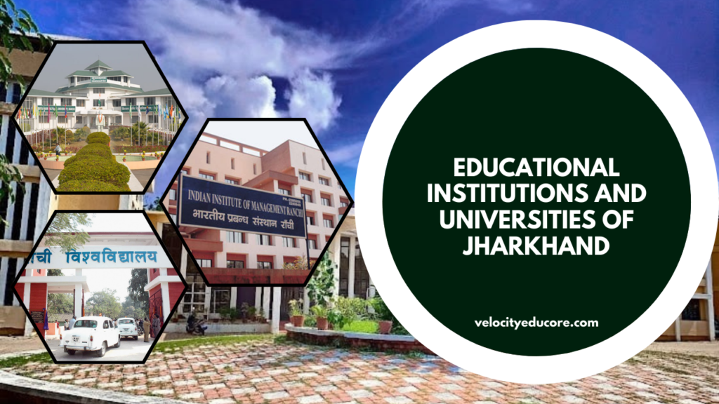
- Ranchi University, Ranchi
- Sarala Birla University, Ranchi
- Sido Kanhu Murmu University, Dumka
- Vinoba Bhave University, Hazaribagh
- Autonomous:
- Dr. Shyama Prasad Mukherjee University, formerly Ranchi college
- Indian Institute of Information Technology, Ranchi
- Indian Institute of Management Ranchi
- Indian Institute of Technology (Indian School of Mines), Dhanbad
- National Institute of Foundry and Forge Technology (NIFFT), Ranchi
- National University of Study and Research in Law
- National Institute of Technology, Jamshedpur
- St. Xavier’s College, Ranchi
- Xavier Institute of Social Service (XISS), Ranchi
- Xavier Labour Relations Institute (XLRI), Jamshedpur
- Agriculture:
- Indian Institute of Agricultural Biotechnology, Ranchi
- Engineering:
- Birla Institute of Technology, Mesra, Ranchi
- Birsa Institute of Technology Sindri, Dhanbad
- DAV Institute of Engineering & Technology, Daltonganj
- Indian Institute of Technology (Indian School of Mines), Dhanbad
- National Institute of Foundry and Forge Technology (NIFFT), Ranchi
- National Institute of Technology, Jamshedpur
- Management:
- Indian Institute of Management Ranchi (IIM-Ranchi)
- XLRI – Xavier School of Management, Jamshedpur
- NSIBM – Netaji Subhas Institute of Hotel & Business Management, Jamshedpur
- Medical Colleges:
- All India Institute of Medical Sciences (AIIMS), Deoghar
- Hazaribag College of Dental Sciences and Hospital, Hazaribagh
- Mahatma Gandhi Memorial Medical College (MGM), Jamshedpur
- Medinirai Medical College and Hospital, Palamu
- Phulo Jhano Murmu Medical College and Hospital, Dumka
- Rajendra Institute of Medical Sciences (RIMS), Ranchi
- Shaheed Nirmal Mahto Medical College, Dhanbad
- Shaheed Sheikh Bhikhari Medical College and Hospital, Hazaribagh
- Psychiatry:
- Central Institute of Psychiatry, Ranchi